 Almost the very first thing I did after the removal van dropped off my things was to head in to Falmouth for Science in the Square with the College of Life and Environmental Sciences, showing folk volcanic rocks and helping them to build earthquake-proof buildings from spaghetti and marshmallows. So many people came. It was brilliant and I am already looking forward to next year. I was delighted to hear about the pumice washed up on Swanpool beach and to give away some Hekla pumice as souvenirs. Brian Cameron, thank you very very much for the shake table, it is already getting well used.
 Geography in Cornwall: Headed south for a change
I have a new job, as a lecturer in the Department of Geography at the University of Exeter on the Cornwall campus near Falmouth. So, far everyone is friendly, the sun is shining, the campus is beautiful and I am getting ready for my first lectures in Environmental Science and the first year fieldcourse to West Penwith.
Almost the very first thing I did after the removal van dropped off my things was to head in to Falmouth for Science in the Square with the College of Life and Environmental Sciences, showing folk volcanic rocks and helping them to build earthquake-proof buildings from spaghetti and marshmallows. So many people came. It was brilliant and I am already looking forward to next year. I was delighted to hear about the pumice washed up on Swanpool beach and to give away some Hekla pumice as souvenirs. Brian Cameron, thank you very very much for the shake table, it is already getting well used.
Almost the very first thing I did after the removal van dropped off my things was to head in to Falmouth for Science in the Square with the College of Life and Environmental Sciences, showing folk volcanic rocks and helping them to build earthquake-proof buildings from spaghetti and marshmallows. So many people came. It was brilliant and I am already looking forward to next year. I was delighted to hear about the pumice washed up on Swanpool beach and to give away some Hekla pumice as souvenirs. Brian Cameron, thank you very very much for the shake table, it is already getting well used. The Hekla 2000 tephra deposit: Grain-size characteristics and eruptive parameters
Abstract UV 1 from Nordic Geological Winter Meeting 2012
Kate Smith, Costanza Bonadonna, Thorvaldur Thordarson, Ármann Höskuldsson, Guðrún Larsen, Stefán Árnason, Freysteinn Sigmundsson
The highly active volcano Hekla last erupted in 2000 and current crustal deformation indicates that the next eruption may be soon. Hekla eruptions usually begin with a short subPlinian to Plinian explosive phase. The associated volcanic plume can cause disruption to air-traffic while tephra fall can affect the environment and infrastructure nearby. The total grain size distribution (TGSD) of tephra and the erupted mass and volume are important input parameters for models used for forecasting dispersal and ash concentration in the volcanic plume, as well as hazard and risk evaluation. This paper presents new calculations of eruptive parameters for the Hekla 2000 eruption, new tephra grain size data and TGSDs.
Haraldsson (2000) and Höskuldsson et al. (2007) calculated Hekla 2000 tephra volumes but with considerably different results.
New calculations, based on mass loading data (Haraldsson, 2000) and reassessment of the isomass map, result in an erupted mass value between 7.8 x 10⁹kg and 2.3 x 10¹⁰kg, depending on the method used. The associated volume lies between 1.1 and 3.3 x 10⁷m3, corresponding to a dense rock equivalent volume of 2.9 to 8.5 x 10⁶m3 and VEI 3.
The eruption deposited tephra with a main dispersal axis to the north and a minor dispersal axis to the south. Tephra was sampled by Icelandic scientists and members of the public within days to weeks of deposition. Granulometric analysis was performed on 31 samples using hand sieving and laser diffraction. This data was used to construct TGSDs using weighted mean and Voronoi Tessellation methods.
Median diameter decreases with distance from the vent from medium-grained lapilli (15.24mm) in the proximal zone, falling sharply over 30km to coarse-grained ash (1.85mm) and then gradually fining to 102μm on Grímsey (294km distance). Proximal to medial distributions are generally weakly bimodal, whereas
peripheral samples and most samples more than 60 km from the vent are unimodal or very weakly bimodal. Spatial variations in mode and fine ash concentration are interesting. The majority of the samples have 2% or less fine ash (<63μm). owever, concentration of fine ash is distinctly higher in two domains; 8 to 12 wt% of fine ash is found within 20km west of the vent, and 4 to 8% fine ash is found from 80 to 190km north of the vent. The bimodality and fine ash concentration variations can be attributed to different transport pathways, deposition from different eruptive phases, aggregation of fines, multiple fragmentation mechanisms and reworking; the nature and contribution of these will be discussed. Sorting values improve with distance from the vent, ranging from 2.04 to 0.70 along the dispersal axis and reflecting effective fractionation of the coarser clast populations by transport and deposition.
All TGSDs determined for Hekla 2000, using these analyses, are bimodal, but different TGSDs emphasise the bimodality and the proportion of fine-grained ash more than others. The TGSD has a significant impact on dispersal model results and it is therefore important to understand the impact of different techniques and sampling patterns for local and international hazard assessment.
The Hoftorfa tephra: a 6th Century tephra layer from Eyjafjallajökull
Abstract SÞ3-5 from Nordic Geological Winter Meeting 2012.
Kate Smith, Andrew Dugmore, Kerry-Anne Mairs, Thorvaldur
Thordarson, Costanza Bonadonna, Guðrún Larsen, Anthony
Newton
Eyjafjallajökull tephra was brought to worldwide attention and put under detailed scientific scrutiny with the eruptions of 2010. Previous historical eruptions have been studied in some detail also, but until recently few details have been known about prehistoric explosive activity. Tephrochronological investigations have shown that explosive activity from the central crater of Eyjafjallajökull in the mid-6th century AD produced a distinctive tephra deposit, the Hoftorfa tephra (also previously known as Layer H or E500). This paper describes this tephra layer, it’s distribution and volume, based on over 100 profiles from south
Iceland.
The Eyjafjallajökull Hoftorfa eruption produced a pale white to yellow, silicic tephra that is thickest on the northern flanks of the volcano. The tephra deposit generally has a matrix of medium to fine grained ash supporting coarse grained ash to lapilli and in some locations bedding and grading are apparent. The extent of the tephra is similar to the Eyjafjallajökull 1821-3 eruption though it is somewhat greater in volume and is considerably thicker on the northern flanks. It is significantly smaller in volume and area than the 2010 Eyjafjallajökull tephra. Hoftorfa (the bedrock outcrop anchoring the north east margin of the great terminal moraine of Gígjökull) is proposed as the type site for this tephra layer being close to its thickest point and easily accessible for further study, following Dugmore (1987; 45).
Deposits have only been found within 20 km of the crater, but being highly visually distinctive, the Eyjafjallajökull Hoftorfa tephra layer still forms a very useful key marker horizon in the late prehistoric geological record, covering at least 600 km2 including the forelands of 8 major outlet glaciers from two separate icecaps.
Despite being of a limited volume and visible extent this tephra is important because its identification extends the record of known activity in the central crater of Eyjafjallajökull from the 17th century AD to the 6th century AD. It shows that the style of activity observed in 1821-3 also occurred some 1300 years previously; moreover, the same stratigraphic sections that have been used to identify this tephra also show that no similar events have taken place in the last c.7000 years.
Eyjafjallajökull tephra fieldwork, July 2011
What a great trip. We got lots of samples that we wanted and were blessed with the weather. The Landrover didn´t break down, we saw old friends and old haunts and explored some beautiful places that I had never seen before.
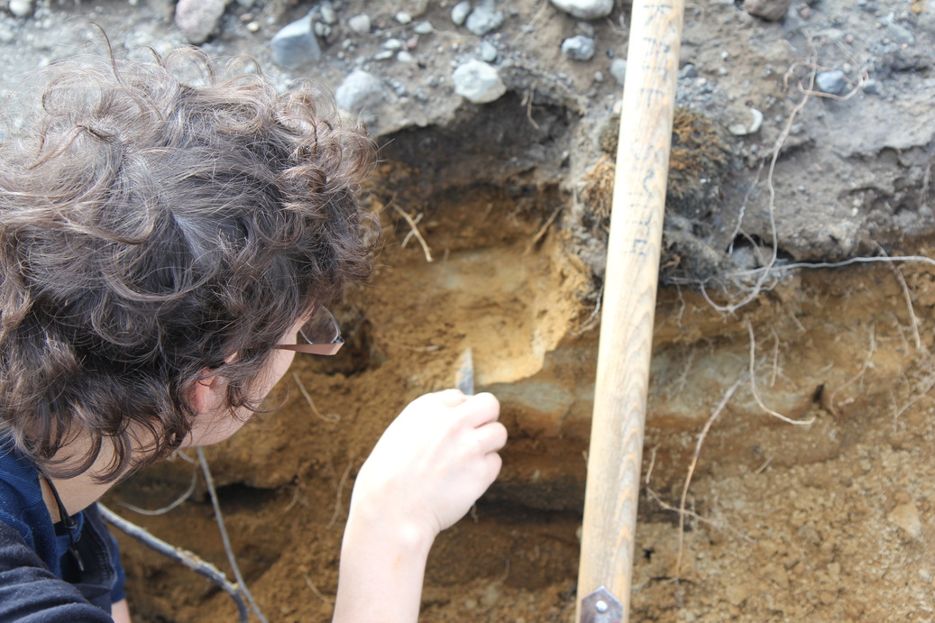 |
| Sampling Layer H tephra from Eyjafjallajökull, deposited around 1500 years ago |
We should now have enough data points of thickness and samples for grain size analyses and deposit density to make significant progress with plans.
 |
| Eyjafjallajökull 2010 and Grímsvötn 2011 tephra being blown around |
Some things that really struck me while we were away are a) that exponential thinning of tephra layers is certainly very close to being how things are (wow, it is hard to find where the layer goes from a trace to zero!), b) Þórsmörk is stunning especially if you cross a few dodgy looking paths and head away from the tourists, c) tephra blows around a lot after it is deposited so how can we assume geological records are good representations of the actual tephra at time of deposition? and d) Fieldwork is great and even better with good company (thanks Iveta).
 |
| Camping near Gígjökull: note the heather has coped least well with the recent ash falls |
 |
| Katla in the distance under the ice cap Mýrdalsjökull. This is the Markarfljót, route of many prehistoric jökulhlaups. |
Hekla 2000
From Iceland to Geneva to finish off grain size analyses of Hekla 2000 tephra...
This Hekla 2000 project has been a really fun learning experience for me, going from using tephras primarily to correlate and date other deposits to specifically looking at the tephra itself. It is amazing what you can find out about a past eruption from some bags of tephra.
Samples of Hekla 2000 tephra were collected shortly after the eruption by Guðrún Larsen at the University of Iceland and other scientisits and members of the public in Iceland. It is quite unusual to have such fresh material to look at and this means that we can look at the tephra itself, hopefully reducing complications of years of reworking, compaction and contamination.
During this project I have worked with Costanza Bonadonna at the University of Geneva who has given me a lot of training and encouragment, as well as Sebastian Biass at the University of Geneva, Guðrún Larsen, Ármann Höskuldsson and Freysteinn Sigmundsson at the University of Iceland. Initial funding came from Landsvirkjun (Icelandic energy company) and the University of Iceland postdoctoral fund.
We have:
- carried out grain size analyses on 31 new samples of Hekla 2000 tephra and estimated the total grain size distribution,
- carried out grain size analyses on 2 samples collected near Hekla in October 2008,
- analysed the componentry of the deposit and the density of tephra clasts,
- re-considered the isomass mapping of the deposit and estimated volume and mass,
- investigated mass eruption rate,
- produced hazard curves for selected sites in southern Iceland for a VEI3 eruption of Hekla (Seb Biass)
Subscribe to:
Posts (Atom)